SUBREGION GUIDE
Big Sur
Rugged coastline where mountains plunge into Pacific waves
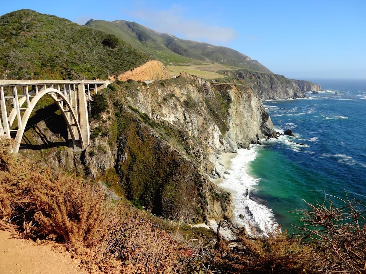
Big Sur isn't just a destination—it's a 90-mile stretch of California coastline that feels like the edge of the world. Here, Highway 1 clings to cliffsides while redwood forests tower above and the Pacific crashes into rocky shores hundreds of feet below. This is where tech executives come to disconnect, artists find inspiration, and couples escape for romance that rivals any European getaway. But Big Sur demands patience. The drive is slow, the fog rolls in without warning, and cell service disappears for miles. That's exactly the point.
Big Sur stretches from Carmel Highlands in the north to San Simeon in the south, though most people focus on the central 50-mile section. The Santa Lucia Mountains rise directly from the ocean here, creating some of the most dramatic coastal scenery in North America. Highway 1 is the only way through, and it's engineering marvel that took 18 years to complete. The road hugs cliffsides, crosses concrete arch bridges, and winds through redwood groves that block out the sun. Expect to average 25 mph on a good day. After winter storms, sections close entirely—sometimes for months. The coastline faces west, which means you'll get those famous California sunsets but morning fog is almost guaranteed. Inland, the mountains climb to over 5,000 feet, creating microclimates that shift from coastal scrub to redwood forests to oak woodlands within miles.
Money-Saving Tips
- 1.Book accommodations months in advance—Big Sur has limited lodging and prices reflect the scarcity
- 2.Fill up your gas tank before entering Big Sur; stations are scarce and charge premium prices
- 3.Pack lunches and snacks from Carmel or Cambria to avoid resort-priced dining for every meal
- 4.Visit during weekdays when possible—weekend rates can be 50% higher at hotels and restaurants
- 5.Download offline maps and entertainment since cell service is spotty and data roaming charges add up
- 6.Consider camping at state parks like Julia Pfeiffer Burns for budget-friendly stays with million-dollar views
- 7.Many attractions like McWay Falls are free—focus your spending on unique experiences like hot springs
- 8.Buy groceries outside Big Sur; the village store charges $8 for a bag of chips
Travel Tips
- •Check road conditions on Caltrans before you go—Highway 1 closures can last for months
- •Start your drive early to secure parking at popular viewpoints like Bixby Creek Bridge
- •Bring layers; coastal fog can drop temperatures 20 degrees within minutes
- •Book dinner reservations well in advance, especially at Nepenthe and Sierra Mar
- •Keep your gas tank above half full—stations are few and far between
- •Download offline maps and music; cell service disappears for long stretches
- •Pack a flashlight for evening walks; most areas have no street lighting
- •Respect private property signs; much of the coastline is privately owned
- •Bring cash; some smaller establishments don't accept cards
- •Plan for slow driving; the speed limit is 55 mph but you'll rarely reach it
Frequently Asked Questions
The full stretch from Carmel to San Simeon takes 3-4 hours without stops, but plan a full day to enjoy the scenery and attractions. Most visitors focus on the central section, which takes 1-2 hours of driving time.