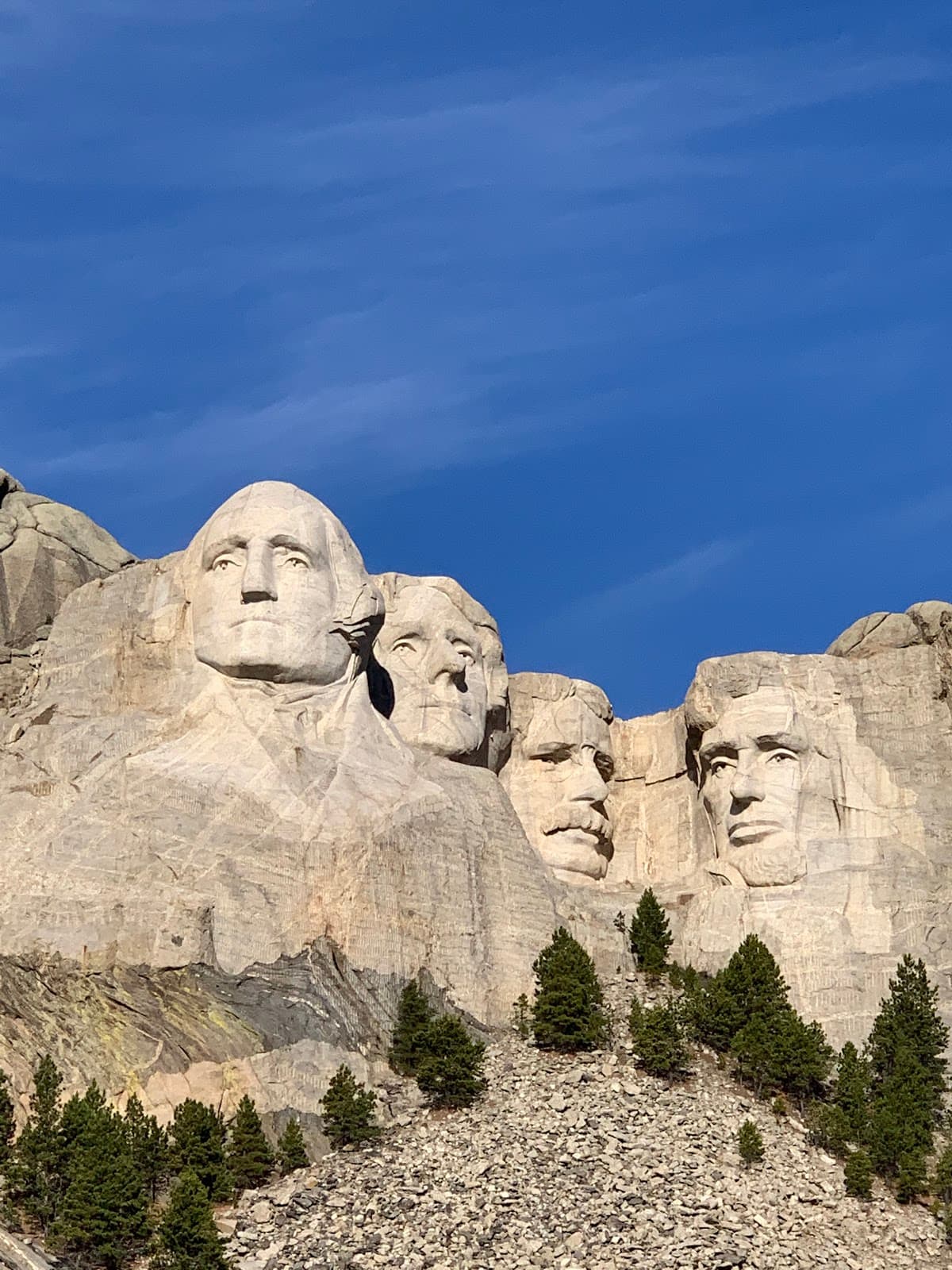
Mount Rushmore
America's monumental tribute carved into sacred Black Hills stone
Four presidential faces stare out from the granite cliffs of Mount Rushmore, and honestly? The photos don't do it justice. This isn't just a roadside attraction — it's a 60-foot-tall testament to American ambition carved directly into sacred Lakota land in South Dakota's Black Hills. Look, you'll spend maybe two hours at the actual monument, but the surrounding area offers caves, wildlife, and some of the best hiking in the Midwest. The crowds are real during summer, but there's something undeniably powerful about standing beneath Washington, Jefferson, Roosevelt, and Lincoln carved into living rock.
Best Months
MAY – OCT
~24°C · moderate crowds
Culture & Context
SACRED GROUND, CONTESTED PAST
Mount Rushmore sits on land the Lakota Sioux consider sacred. Paha Sapa, the Black Hills, was guaranteed to the Lakota by the 1868 Fort Laramie Treaty. Then gold was discovered.
The U.S. government took it back.
That tension doesn't disappear when you look at four presidents' faces carved into it. Sculptor Gutzon Borglum chose Washington, Jefferson, Lincoln, and Theodore Roosevelt to represent the nation's founding, expansion, preservation, and conservation. Work ran from 1927 to 1941.
About 400 workers dynamited and chiseled roughly 450,000 tons of granite. Nobody died during construction, which is remarkable given the 60-foot faces and lack of modern safety gear. The nearby Crazy Horse Memorial, started in 1948, is still being carved just 17 miles away.
It's a direct Indigenous response to Rushmore, and worth the detour. South Dakota calls itself "The Mount Rushmore State" — the monument is genuinely central to regional identity, not just a marketing hook. Don't overlook the Lakota cultural presence throughout the Black Hills.
Powwows, museums, and Native-owned businesses are part of this landscape, not a footnote to it.
Local Customs
WEST RIVER GRIT, STURGIS CHAOS
Say 'The Hills' and everyone knows you mean the Black Hills. No need to elaborate.. Locals say 'crick' not 'creek.
' Spell it wrong, say it right.. 'You betcha' functions as yes, you're welcome, and absolutely — use it freely.. In rural SD, 'lunch' is what outsiders call 'dinner,' and 'dinner' is what everyone else calls 'supper.
' Don't show up for dinner at noon expecting an evening meal.. Lakota word 'Pilamayaye' (pee-lah-MAH-yah-yeh) means thank you. People appreciate the effort if you try..
West River vs. East River is a real cultural divide. The Missouri splits South Dakota in two.
West River (Black Hills side) leans ranching and rugged independence. East River is farming country. Locals know which side you're from within about two minutes..
During Sturgis Rally week in August, do not assume you can just grab a last-minute hotel room anywhere in a 100-mile radius. Plan way ahead.. 'Touron' is local slang — a blend of tourist and moron.
Don't be one. Read trail signs, don't feed wildlife, and yield to bison on the road.
Safety
SUDDEN STORMS, WILD BISON
Weather in the Black Hills changes fast. Summer afternoons bring severe thunderstorms, sometimes with hail and lightning, often with very little warning. If you're on the Presidential Trail or any exposed hiking path and the sky turns green-gray, get back to a structure.
Temperatures can drop 20–30 degrees in under an hour during a storm. Bison and other wildlife are genuinely wild. In Custer State Park, bison approach vehicles and have gored tourists who got too close for photos.
Stay 100 yards minimum. They look slow; they are not. Mountain roads like Iron Mountain Road have sharp hairpin turns and no guardrails in some sections.
Drive it in daylight, especially if you're unfamiliar with mountain driving. The July 3 fireworks event has a strict prohibited items list, security screening for all attendees, and no firearms allowed on shuttles. The lottery ticket holder must be personally present for their party to enter.
Altitude in the Black Hills ranges from 3,000 to over 7,000 feet at Black Elk Peak — stay hydrated, especially if you're coming from sea level.
Getting Around
CAR REQUIRED, SCENIC DRIVE
There is no public transit to Mount Rushmore. You need a car. The main approach is Highway 244 west of Keystone.
If you're coming from Rapid City (~25 miles), take Highway 16 south and then 16A west. Do not sleep on Iron Mountain Road (Highway 16A south from Keystone into Custer State Park) — it has pigtail spiral bridges and tunnels deliberately framed to put the monument in the picture as you drive. It takes longer but it's worth it.
For the July 3 fireworks event specifically, shuttle buses run from Rapid City (about a one-hour ride) for lottery ticket holders who chose the shuttle option. There are no return trips to Rapid City until after the event, so plan accordingly. Rapid City Regional Airport (RAP) is the nearest commercial airport with connections to Denver, Dallas, Minneapolis, and Chicago.
Car rentals are available at RAP. During Sturgis Rally week, the highway network through the Black Hills fills with motorcycles. Iron Mountain Road and Needles Highway become especially slow-moving.
Build in extra time for any drive during that window.
Useful Phrases
Where to Stay in Mount Rushmore
1 recommended properties
Itineraries coming soon
We're working on adding amazing itineraries for Mount Rushmore. In the meantime, try the app to create your own!
Money-Saving Tips
- 1.Park entrance costs $10 but covers an entire year — save your receipt if you're visiting other national sites
- 2.Stay in Rapid City instead of Keystone to save $50+ per night on hotels
- 3.Pack lunch and snacks — food prices inside the monument area are inflated
- 4.Buy the America the Beautiful Annual Pass for $80 if visiting multiple national parks
- 5.Gas up in Rapid City before heading to the monument — prices jump $0.30 per gallon in tourist areas
- 6.Many Black Hills attractions offer combo tickets — check for deals if visiting multiple sites
Travel Tips
- •Arrive before 9am in summer to beat crowds and find parking
- •Download the Mount Rushmore audio tour app for free guided commentary
- •Bring layers — mountain weather changes quickly even in summer
- •The Presidential Trail gets you closest to the monument faces — it's a half-mile walk
- •Iron Mountain Road tunnels frame the monument perfectly but are narrow — take your time driving
- •Check weather before visiting — fog can completely obscure the monument
- •The visitor center museum tells the carving story better than most guidebooks
- •Evening lighting ceremony runs nightly in season — arrive 30 minutes early for good seats
Frequently Asked Questions
Explore Mount Rushmore
BUILD YOUR
MOUNT RUSHMORE PLAN
Insider picks, smart timing, and a plan ready when you are.
Start Planning